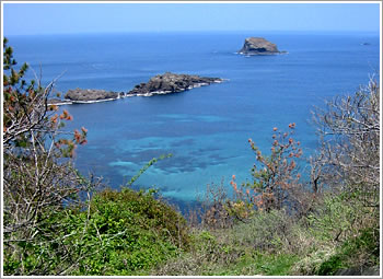
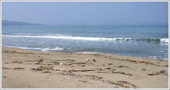
Sodwana Bay to Royal Natal NP

Full day of driving today as we travel from Sodwana Bay (north of St. Lucia on the map) south along the coast towards Durban before cutting across towards the Drakensberg mountains. We’ll be spending two nights in Royal Natal and one in Golden Gate Highlands NP, hiking in the mountains during the days. Just now nearing the point on the drive where we veer west, away from the coast. A beach has been selected for one last swim in the Indian Ocean.
Driving to Swaziland

On the first day of our driving tour, we took a wrong turn in the mountains heading over a dirt road pass to Swaziland, fairly quickly corrected course, but then realized we would miss the 4pm border crossing closing time. Took the road less traveled heading to another crossing a few hours south and ended up passing through beautiful mountains and valleys, with smiling people everywhere and gorgeous scenery. Passed several soccer games, young boys flying kites in the setting sun by the side of the road, workers walking home, cows and monkeys and goats, and miraculously managed to not damage our tiny VW Polo on the rough dirt roads. Arrived at the border just before dark, misunderstood directions from a border guard and ended up driving through a small housing settlement rather than parking the car, much to everyone’s amusement. Another 45 minutes drive back north in Swaziland brought us to Phophonyane Falls Nature Reserve where we made our way through a dark, quiet forest to what seems at night like an African fairy wonderland of lit trails through the woods, tents and our beehive hut. We’ll be here two nights.
Selati wildlife
A list of wildlife seen at Selati: elephant, rhino, lions, leopard, baboon, vervet monkey, zebra, giraffe, caracal, genet, African wild cat, bushbaby, spring hare, jackal, honey badger, mongoose, hyrax, warthog, ostrich, wildebeest, bontebok, springbok, impala, waterbuck, duiker, nyala, bushbuck, eland, kudu, sable, steenbok, klirspringer.
Selati Game Reserve
Selati Game Reserve, approximately 66,000 acres of land west of Kruger National Park, is a partnership between 11 families who combined their properties - mostly land that had previously been used for farming or ranching. We’re staying at the home of our hosts, Rob and Judy Snaddon, along with a handful of other guests. The daily routine is to wake up in the five o’clock hour and head out to look for wildlife by six. We climb into a modified Land Cruiser that has four rows of open air stadium-style seating, and drive the many single lane dirt roads that wind through the property. Because of the elephants, rhinos and big cats, it’s too dangerous to walk without a guide with a firearm. (The living compound is surrounded by electrified fence.) We return for lunch and co afternoon nap during the hot hours of the day, and then head back out just before sunset for several more hours. The scope and grandeur of the landscape has been difficult to capture in photos.
Evening at Selati
It’s three days into autumn here, there’s a full moon tonight, and there will be a lunar eclipse in a few hours. We’ve been out game watching for several hours now - no luck with the lions tonight though we were very close. A giraffe just stepped into the road, illuminated in our headlights and handheld spotlights, less than 20 feet from us. Four or five others were visible in the trees nearby.
South Africa Travel Map (updated)

Leaving tomorrow for the Selati Game Reserve in the northeast. Flying from Cape Town through Johannesburg to Neslruit, where our gracious hosts will pick us up for the drive north.
We’ve been fleshing out our driving tour and making some reservations for accommodations. Looking forward to spending time in both Lesotho and Swaziland, as well as a day or two on the Indian Ocean coast north of Durban.
Helderberg Mountain Hike
I got a bit scortched on our five-hour hike up Helderberg Mountain today. I prefer to think of it as a stong base tan rather than, as someone described it tonight, “looking like a ripe tomato.”
It was a beautiful hike, made even better by the great meal at Guardian Peak restaurant on a vinyard just below the mountain after the descent. It’s amazing the quality of food and wine you can get here for next to nothing, at least compared to Seattle prices.
Cape Town Area Map

Above is a map of the Cape Town area. I’m staying in Gordon’s Bay, which is about a 40 minute drive from the city center. Most of the area between the two is developed as suburbs. I’ve added a few other areas that we’ve traveled to (or, in the case of Table Mountain, will be going to in the next week).
Photos of our hike in the Jonkershoek Nature Reserve have been posted to Flickr. Same for the trip down to Betty’s Bay and then back up through Franschhoek and Stellenbosch the other day.
We’ll be heading into the city to stay for Saturday, Sunday and Monday. Looking forward to an international design expo that’s taking place this week.
Sandboarding
Betty’s Bay, near Cape Town. This is just a series of still shots, not a movie.
South Africa Travel Map

This is a travel map for the trip as it stands now (click the image to see a larger version on my Flickr site). The driving portion of the trip is still in the planning stages. The route shown on this map roughly corresponds to the route that will bring us back to Cape Town from Nelspruit.
Flying to South Africa
Despite being long (around 30 hours of flying time over 42 hours of travel time), the trip to Johannesburg was comfortable. A shower, dinner and drinks at the Hong Kong airport made that five-hour stopover enjoyable. (On the return trip, we’ll have time to go into the city when we land in Hong Kong.) I slept for 11 of the 12 hours between Hong Kong and Johannesburg.
We arrived in Johannesburg around 6:30am and got through the airport quickly, though without my checked bag. It got lost along the way, but was delivered to me the next morning with everything in good condition.
It took at least four days to get over the worst of the jet lag, but we had a great host in Johannesburg who made the transition very comfortable.
New photos posted
I’ve got my local mobile account up and running here in South Africa, so I’ll be posting daily snapshots from my phone camera. I also just uploaded photos from my regular digicam, which is something I’ll only be able to do occasionally. The first batch covers Johannesburg through the first day in Cape Town.
Back up and running, just in time for South Africa

I leave in about four hours for South Africa, where I’ll be spending six weeks. In honor of my new adventure, this web site has been resurrected from the dead. As you can see from the previous entry, it’s been more than two years since my last post.
I’ll be arriving in Johannesburg at some unspecified (long) time in the future. Two days? One day? Who knows. It’s going to be a long flight, with a brief stop-over in Hong Kong. There won’t be much here for the next few days, but after that I hope to be adding words and photos often. Come back again when it’s more interesting.
Another Day, A Different Angle
What a difference a little sunshine, blue sky and shot composition can make.
Back In The Arctic
I first arrived in Kotzebue in January 1993, landing in the winter darkness in the midst of a snowstorm. I meant to only stay for several months, but ended up living here for two and a half years — first as editor of the local newspaper, then striking out on my own doing desktop publishing work.
I’m back, now, for two days, and it’s much milder weather today, if you can call temperatures in the mid-40s in July mild. As the plane landed around 11 a.m., the local temperature was 39 degrees — I was wishing I hadn’t left my jacket behind as I rushed out of the house in Anchorage this morning.
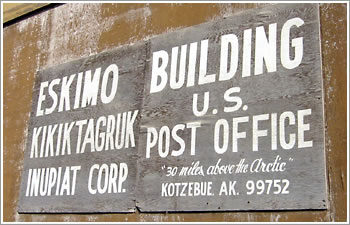
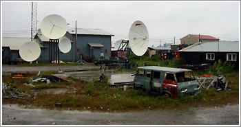
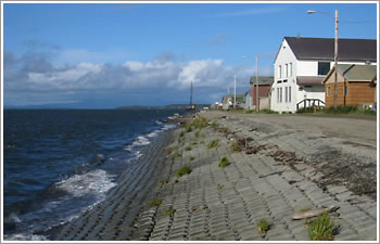
Kotzebue is a town of about 3,000 people — mostly Inupiat Eskimos — located 30 miles above the Arctic Circle and not connected to the rest of the world by road. The only way in and out of the area is by plane — Alaska Airlines flies several 737 jets a day between Kotzebue and Anchorage, 550 miles to the south. The town is located on a gravel spit at the tip of the Baldwin Peninsula, which juts out into Kotzebue Sound, which in turn leads into the Bering Sea.
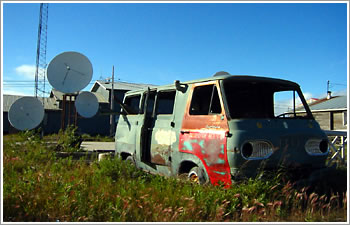
Kotzebue is not what you’d call picturesque (the beautiful areas of this region are across the Sound on the mainland). But I was lucky to have a bit of blue sky blow in tonight, so I went out to see if I could capture some shots that would put a good face on this little arctic burg.
The Weather Ain't So Hot
Despite (and maybe because of) the fact that I lived in Alaska for about 16 years, I’ve never been a big fan of the weather. Most people would take that to mean the winters are cold and miserable — which they can be. But I’ve never thought much of the summer weather, either. The best I could say for summer in most parts of Alaska is that sunshine and warmth are more likely than in winter. That’s not saying much.
This summer has been an unusually nice one in much of the state. But again, that’s relative, and there’s still plenty of bad weather, as well.
We got lucky with weather on our trip out into Denali National Park. Our warm, sunny week was sandwiched between two storms that dumped unusual levels of rain in the interior of Alaska, where Denali is located.
Floods slam Interior a 2nd time
Anchorage Daily News
Road crews struggled Monday to keep parts of the Parks Highway open while cabin owners near Denali National Park and Preserve tied steel cables to their structures to keep them from floating away after a storm dumped more than five inches of rain on parts of the Interior over the weekend.The storm caused flooding along several creeks from Cantwell to north of Fairbanks, the National Weather Service said.
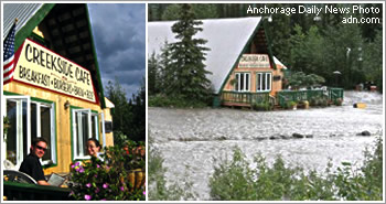
The photo on the left in the collage above shows an evening last week when we dined on the patio of the Creekside Cafe, near where my mother lives outside of Denali. The photo on the right is from a few days ago, after rains swelled nearby Carlo Creek and flooded the area.
Alaska has some amazing things going for it — weather is not one of them.
Visiting Denali

I’m in the midst of a two-week stay in Alaska, visiting family and enjoying my childhood haunts. I’m traveling with my sister, Heather, and her boyfriend, Chris.
We spent the first week in Denali National Park, visiting my mother at Camp Denali, where she works. This week we’re down in Anchorage with my father and step-mother. Later this week, I’ll fly on business up to Kotzebue, an Inupiat town above the Arctic Circle where I lived for two and a half years in the early 1990s (and where the Goo Goo Dolls recently shot a music video).
I didn’t get a chance to post anything here last week, so I’m just going to share a few things about my time in Denali now. (You can see photos in the Photos & Flicks section.)
BACKGROUND
My family moved to Denali National Park and Preserve (then called Mt. McKinley National Park) in 1976, when I was seven years old. My father worked as the mountaineering ranger at the park, managing climbing expeditions and coordinating rescues when climbs went bad (and, on the less glamorous side, leading garbage-cleaning expeditions). We lived in the park for eight years before moving on to another part of Alaska.
Our family friends, Wally and Jerri Cole, purchased Camp Denali around the same time we moved to Alaska, and my family occasionally spent time out at Camp during summers (the only time the facilities operate). Both of my sisters worked at Camp for seven or eight summers, and my mom has been working for the Coles now for ten years. I’ve never worked at Camp — I just take advantage of the family connections and visit every couple of years (Thanks Wally and Jerri!).
To say Camp Denali is in a good location is an understatement one could never understand without visiting. It’s situated on private land that was once at the very edge of the national park, but which now lies surrounded by a park that was expanded in 1980. It’s at the end of the only road into the park, and it has a view of Mt. McKinley that is unparalleled.
LOWELL THOMAS JR. AND TIBET
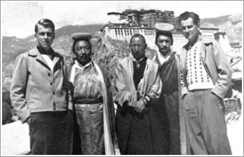
During our stay at Camp Denali, renowned Alaskan bush pilot (and frequent visitor to Camp Denali) Lowell Thomas Jr. showed guests an old television special featuring his trip to Tibet in 1949 with his father, Lowell Thomas. The two men were among the first Westerners invited by the then-hermit nation to visit and to meet the Dalai Lama. The footage was incredible, as was the story of their trek into and out of Tibet. Lowell Sr. broke his hip in a fall from a horse on the return trip, and had to be carried in a stretcher for 20 days back to India.
A WOLF AND KILL
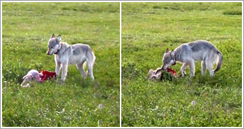
It’s common to see grizzly bears and caribou from the one gravel road that winds into Denali National Park. It’s much less common to see a wolf, as they tend to be skittish about any kind of human contact. So it was a rare thing to see a wolf just ten feet off the road during our return trip through the park. It had just killed a caribou calf, and was resting after feeding. Four caribou sat resting about half a mile further up the hillside, part of the group that the wolf had taken the calf from. After sitting for a while, the wolf got up, walked alongside us, across the road and back to the kill to feed some more.
AND…
Also saw plenty of grizzly bears, had spectacular weather, did lots of hiking, enjoyed good food and company, and had a fun overnight camping trip into the backcountry.
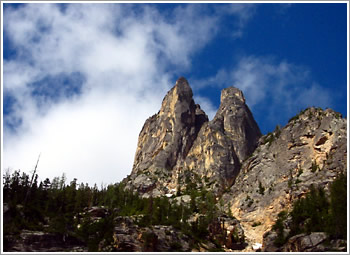
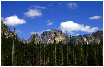
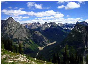
North Cascades
I took a quick, overnight trip up to the Methow Valley, just on the east side of the North Cascade mountains. The weather and scenery were beautiful, as usual. If felt great to be back in this terrain.
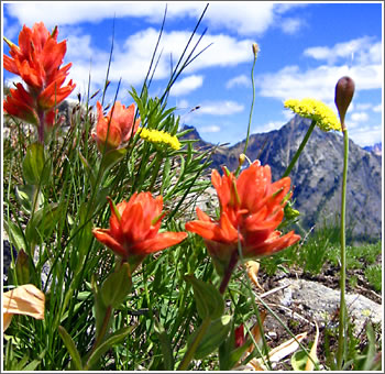
Too bad the focus is a bit off on the photo of the flowers above…
The first two shots below were taken from the North Cascades Scenic Highway near Washington Pass. The third was taken during a hike nearby.
Korean Soldiers
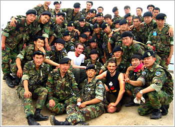
While in Korea, on an overnight trip to Songnisan National Park, my friend, Jason, and I encountered a troop of Korean soldiers on a training hike. We met at the top of a mountain, on a rock formation that acted as a viewing platform for the surrounding countryside.
The soldiers pretty much ignored us until I asked if I could get a photo with some of them. Within seconds, we were surrounded by the whole troop.
Okinawa
Today is our final day in Okinawa. The visit has been all about beaches — not much cultural touring. Three nights of camping, two on a beautiful stretch of beach with no other campers. The north part of the main island is beautiful, once you get away from the ugly sprawl of Naha and Okinawa City. Unfortunately, the architecture here is even uglier than in the rest of Japan — everything is built to look like a concrete bunker. The American military presence is impossible to miss, even on the more remote beaches as military planes and helicopters fly overhead at regular intervals. But it is still possible to find more secluded beach areas on the main island. Wish we’d had more time to get to some of the more remote islands. I could easily spend another week or two here.
Back to Tokyo this afternoon.
Visiting The DMZ
My visit today to one of the world’s most militarized zones included a Disneyland-like ride down into the earth, a luncheon in a touristy restaurant with a view of miles of barbed wire fencing and a soundtrack featuring Janet Jackson singing Nasty, and a little Korean boy whose aunties thought nothing of letting him bring — and incessantly use — a toy space gun that made loud machine gun sounds as we drove through checkpoint after checkpoint of armed guards.
The demilitarized zone (DMZ) separating North and South Korea is both a chilling reminder of the region’s tensions and a somewhat chintzy tourist attraction.
Missed The Earthquake, There Will Be No Invasion This Week, And There Is No SARS in Korea
I missed the earthquake by just a few hours. For the past couple weeks, I’ve been imagining I feel low-level earthquakes, though as far as I could tell there were never actual quakes. This happened several times, and has had me expecting a good shake before I left Japan. But my flight left too early.
I’m in Seoul now. On the agenda for tomorrow is a visit to the border with North Korea, including a tour of one of the underground tunnels built by the North for use in an invasion of the South.
One more thing, for those who might worry — there are no SARS cases in South Korea (I can’t count the number of times I had to explain this to Japanese friends when I told them of my travel plans).
Three Weeks Of Travel
Monday morning I hit the road. I’ll be traveling for three weeks, mostly in Japan with a quick trip over to South Korea.
05/26 — 05/30 : in Seoul, South Korea
05/30 — 05/30 : Arai, Japan, to see the Kodo drummers
05/31 — 06/02 : back to Sado Island
06/03 — 06/07 : in Okinawa, beach vacation!
06/08 — 06/12 : in Tokyo and surrounding areas
Visit To Sado Island
Sado Island (Sado-ga-shima) is a bit off the map in Japan — just the way I like it. Situated about 40 km off the western coast of Japan, Sado is an island where for centuries people — including an ex-emperor — were sent into exile. These days it’s known for its scenery, for views of an older and slower style of Japanese life, and for the famous Kodo drummers.
My mother and I took the train from Nagano to Naoestu on the coast, then a ferry into the small port of Ogi on the southern tip of the island. We stayed for three nights in three different minshuku (Japanese inns), ate loads of fresh seafood for both dinner and breakfast, and drove almost 400km in our rented car while circumnavigating and crossing the island.
The weather was rainy the first day, but cleared into perfect, warm, sunny days after that. Tourists were almost non-existent (too early in the season), so the roads, beaches, mountains and trails seemed relatively deserted. I did my first swim in the Sea of Japan off an empty beach that stretched for several kilometers.
A visit to Sado is highly recommended for those of you here in Japan, and this is the perfect time of year to go.
Japan Travel Map
I’ve made a small update to the neglected Life in Japan section of my site, adding a travel map showing most of the places I’ve visited during my stay in Japan.
From Kyoto
It’s our third night in Kyoto. We decided to stay one more night rather than travel to Nara (we’ll do that tomorrow, for a day-trip before heading home to Nagano).
It’s been an excellent trip. Perfect weather. I’ve got lots of great pictures to post after I get home. Kyoto is beautiful, of course, and it’s been great to have three days here.